By buying this product you can collect up to 155 loyalty points. Your cart will total 155 points that can be converted into a voucher of 31,00 €.
Black and White Photo - Art print
 View larger
Picture information
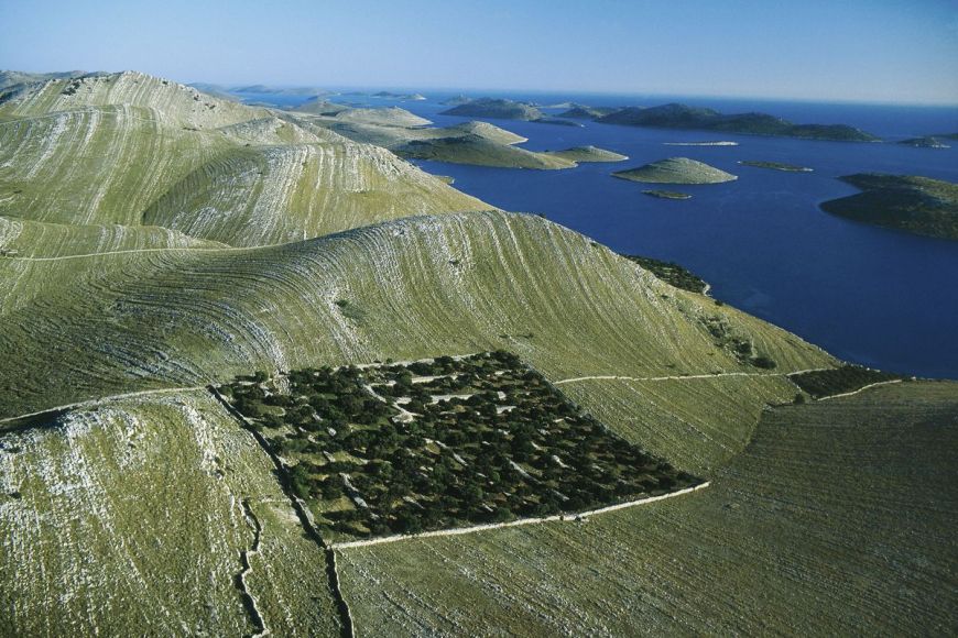
Island of kornat, Croatia
Yann ARTHUS-BERTRAND
Art Photography by Yann ARTHUS-BERTRAND, island of kornat, Kornati national park, Dalmatia, Croatia. The eastern edge of the Adriatic washes the shores of the 150 islands and islets that make up the Kornati archipelago. The largest island, Kornati, is 12.5 square miles (32.5 km2) in area and accounts for two-thirds of the archipelago’s land surface.
Data sheet
| Orientation | Landscape |
| Color | Green |
Island of kornat, Croatia
Yann ARTHUS-BERTRAND
Art Photography by Yann ARTHUS-BERTRAND, island of kornat, Kornati national park, Dalmatia, Croatia. The eastern edge of the Adriatic washes the shores of the 150 islands and islets that make up the Kornati archipelago. The largest island, Kornati, is 12.5 square miles (32.5 km2) in area and accounts for two-thirds of the archipelago’s land surface.
Fine Art Photography
Print by Experts
100 % Made In France
A recognized expertise, a search of permanent quality.
Printed by a professional photographic laboratory.
All prints are made to order, controlled by the Technical Director.
A certificate of authenticity is provided with each photograph.
Framework made by selected materials to give you the best results. every step of the processing is monitoring by experts.
Loyalty points
Gift Card
Don't miss the opportunity to do the best present...
The whole Yann Arthus-Bertrand photos available with Hemisgalerie gift card.
Lets your guest choose the best image.
Amount from 50 €, create and download directly on our website, valid for one year including promotions.
The original gift for all events
More info
The eastern edge of the Adriatic washes the shores of the 150 islands and islets that make up the Kornati archipelago. The largest island, Kornati, is 12.5 square miles (32.5 km2) in area and accounts for two-thirds of the archipelago’s land surface. The fold in the Earth’s crust that formed the Kornati mountain range was produced by the collision of the Adriatic and European tectonic plates. The melting of glaciers and rise in sea levels after the last Ice Age, 20,000 years ago, made the mountains into an archipelago which was then eroded by the sea and the wind, exposing fine striae in the limestone. A century ago, the inhabitants of the nearby islands used these rocks to build dry-stone walls to pen in their sheep and keep them from their olive groves and vineyards. Overgrazing has done considerable damage to wildlife and to the thin vegetation. This desertification contrasts with the richness of the waters around the archipelago, where most of the Mediterranean’s fish and mollusk species can be found. Nevertheless, these too are threatened by fishing, which sometimes uses illegal methods. Almost 30 percent of the world’s fish species are either extinct or facing extinction.